
WMO welcomes release of first image from Europe’s weather satellite
The World Meteorological Organisation (WMO) has welcomed the release of the first image from Europe’s newest weather satellite, which reveals conditions over Europe, Africa and the Atlantic with an extraordinary level of detail.
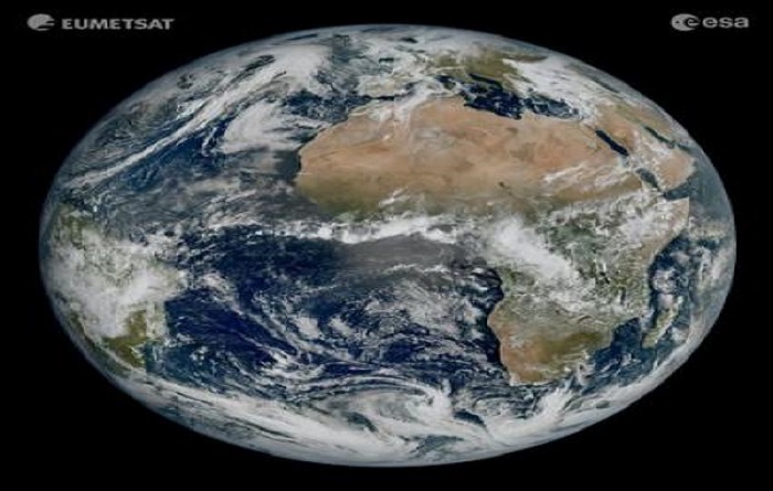
Europe’s meteorological satellite agency, EUMETSAT, and the European Space Agency (ESA) on 4 May jointly released the image from the first satellite in the new generation of European weather satellites, Meteosat Third Generation – Imager 1 (MTG-I1). MTG-I1 was launched on 13 December 2022.
The instruments on the third generation of Meteosat meteorological satellites produce imagery of much higher resolution more frequently than is possible from those on the second-generation spacecraft.
“WMO is looking forward to the benefits that this exciting new instrument will provide when the data becomes operationally available to the members. This will make an important contribution to the Early Warnings For All Initiative (EW4All), in particular on the African continent,” said Natalia Donoho, head, WMO Space Systems and Utilization Division.
The image, captured by the satellite’s imager at 11:50 UTC on 18 March 2023, shows much of Northern and Western Europe and Scandinavia cloaked in clouds, with relatively clear skies over Italy and the Western Balkans.
Details it contains, such as cloud vortices over the Canary Islands, snow cover on the Alps and sediment in the water along the coast of Italy, are not as clearly visible, or not visible at all, in imagery from the instruments on the current Meteosat Second Generation satellites.
Crucially for Nordic countries, the image reveals a greater level of detail of cloud structures at high latitudes. This will enable weather forecasters to more accurately monitor the evolution of rapidly developing severe weather in that region.
“This remarkable image gives us great confidence in our expectation that the MTG system will herald a new era in the forecasting of severe weather events,” EUMETSAT Director-General Phil Evans said.
“It might sound odd to be so excited about a cloudy day in most of Europe. But the level of detail seen for the clouds in this image is extraordinarily important to weather forecasters. That additional detail from the higher resolution imagery, coupled with the fact that images will be produced more frequently, means forecasters will be able to more accurately and rapidly detect and predict severe weather events.”
“The high-resolution and frequent repeat cycle of the Flexible Combined Imager will greatly help the WMO community to improve forecasts of severe weather as well as long-term climate monitoring, marine applications, and agricultural meteorology. It will provide new information on temporal changes of cloud macro- and microphysics, which are important to capture the fast hydrological processes related to clouds and precipitation formation,” said Ms Donoho.
The well-calibrated and -characterized FCI instrument also provides opportunities for ocean monitoring. With its better spatial resolution and more channels in the solar spectrum FCI can deliver improved ocean observations, and the high temporal repeat cycle of the geostationary satellite improves the probability of detecting clear areas and it resolves fast ocean processes such as tidal variability of suspended matter and plankton.
In the area of agricultural monitoring, traditionally polar-orbiting satellite data are used, but FCI can support evapotranspiration and water stress modeling as well as vegetation stress monitoring. As signatures of vegetation stress are manifested in the land surface temperature signal, which can be established by the thermal infrared (TIR) window data, a TIR-based drought index can provide an effective early warning of impending agricultural drought in particular on the African continent.
Director of Earth Observation at the European Space Agency (ESA), Simonetta Cheli, said seeing MTG-I1’s first image was a moment of great pride for the organisation and all those who have contributed to the Meteosat Third Generation programme.
“This image is a great example of what European cooperation in space can achieve,” Cheli said. “The level of detail MTG-I1’s image reveals, unachievable over Europe and Africa from a geostationary orbit until now, will give us a greater understanding of our planet and the weather systems that shape it.
“This image represents not just what can be achieved through European expertise but our determination to ensure the benefits of new technology are felt by communities in Europe and beyond.”
Thales Alenia Space, MTG prime contractor, built the imaging instrument, the Flexible Combined Imager, and integrated the MTG-I1 satellite.
The satellite is currently undergoing a 12-month commissioning phase, in which its instruments are switched on and the data they produce are calibrated. The data from MTG-I1 will be disseminated to meteorological services in Europe and beyond at the end of 2023, for operational use in weather forecasts.
The ground segment infrastructure required to routinely process images was used to produce the first image, as a preview of things to come at the end of the year. Images of the full Earth disc will be produced every 10 minutes when the system is operational.
MTG-I1 is operated by EUMETSAT from its headquarters in Darmstadt, Germany. The satellite was procured by ESA, fulfilling the requirements established by EUMETSAT in consultation with the meteorological services in its member states.