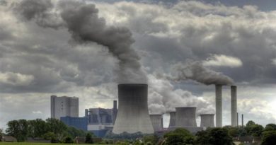
July sees extreme weather with high impacts-WMO
Extreme weather, including record temperatures and heat waves, drought and disastrous precipitation, has marked the first half of summer in the northern hemisphere. This has had widespread impacts on human health, agriculture, ecosystems and infrastructure and led to devastating wildfires.
“2018 is shaping up to be one of the hottest years on record, with new temperature records in many countries. This is no surprise. The heat waves and extreme heat we are experiencing are consistent with what we expect as a result of climate change caused by greenhouse gas emissions. This is not a future scenario. It is happening now,” said WMO Deputy Secretary-General Elena Manaenkova.
The persistency of high temperatures in some regions – including northern Europe – has been due to a stationary high pressure system. This is common in summer in both Northern and Southern Hemispheres. The jet stream, a core of strong winds around 10 kilometers above the Earth’s surface that blow from west to east and which steer weather around the globe – is generally slower in summer and occasionally become weaker than usual, then very settled weather occurs on the surface.
There is much scientific research into whether climate change and substantial changes to sea surface temperature, escalated by high multi-decadal natural variability, are contributing to more profound effect in altering the atmospheric circulation and so leading to more “blocking patterns.”
Drought and heat in northern Europe
WMO’s Regional Association for Europe’s Climate Centre on Climate Monitoring, operated by the German Weather Service, DWD, issued a second Climate Watch advisory with guidance on drought and above normal temperatures valid from 19 July until 6 August. The guidance product, used by National Meteorological Services to issue national warnings and forecasts, referred to “a continuation of the drought situation and above-normal temperatures for at least the next two weeks for northern Europe (from Ireland to the Baltic States and southern Scandinavia).
“The weekly temperature anomalies are forecasted with up to +3 to +6°C (in the first week in parts +6 to +10°C). The probability that precipitation will be below the lower tercile is more than 70% in the first week and more than 50% in the second week. This drought may be accompanied by water scarcity, local thunderstorms, risks of wildfires and harvest losses since soil moisture is reduced,” it said.
Precipitation June 2018
Amid an extended heatwave in Scandinavia, temperatures topped 30°C in the Arctic Circle. Norway saw a record temperature of 33.5°C in Badufoss on 17 July, and it reached 33.4°C in Kevo, Finland. Influenced by a warm wind, the far north of Norway (Makkaur) saw a new record minimum overnight temperature of 25.2°C on 18 July.
The heatwave followed an exceptionally dry and warm May in northern Europe, leading to a a sustained elevated risk of forest fires throughout Scandinavia and the Baltic region. Sweden reported about 50 forest fires burning in mid-July.
Deadly fires fanned by extremely high winds killed dozens of people near Athens on the night of 24 July in one of Greece’s worst tragedies for years. Temperatures on 23 July reached about 38°C and there were strong west winds. Greece, however, has not witnessed below average precipitation so far this summer and so meteorological conditions in Greece cannot be compared to Scandinavia.
Ireland recorded heatwaves at 15 synoptic stations (5 consecutive days or more with maximum temperature over 25°C) and an absolute drought at all its stations.
The UK saw its driest first half of summer on record, with just 47 mm between 1 June and 16 July. The Met Office has said that the heatwave will continue across much of England this week, with temperatures peaking up to 32-34°C in a few places on27 or 28 July.
Armenia saw a heatwave from June 29 to July 12. The average daily air temperature was 4 – 7° C above normal and up to 9°C in some region. A new record temperature of 42.6°C was observed at Areni on 12 July.
The combination of little precipitation and sustained above-average temperatures impacted agricultural production (primarily cereals and hay), while water supply disruptions or restrictions are reported locally. No significant rain is expected until at least mid-July, nor are temperatures forecast to return at normal during the same month, according to the Copernicus European Drought Observatory.
Conversely, southern parts of Europe including parts of Spain, Italy, Greece and Turkey, have been witnessing below average temperatures and above average precipitation for the early part of summer.
The conditions were due to a persistent anticyclone, or high pressure, system blocked over northern Europe. Atmospheric blocking over the northern North Atlantic involves isolation of large regions of air from the westerly circulation for 5-14 days or more.
Atmospheric blocking alters normal climates across Europe and Russia by shifting storm tracks. Typically associated with an anticyclone, the zonal wind pattern known as the jet stream deviates from its mean position and its westerly winds reroute north and south of the anticyclone. Blocking is a typical winter weather phenomena, but it can also influence summer weather patterns as well and it could be linked to extremes such as Russian heat wave in 2010.
Recent analysis suggests that climate change from human activities, also called anthropogenic forcing, might indeed affect the characteristics of blocking events in the Euro-Asia sector, in particular leading to longer blocking episodes.
Another possible player in creating summer atmospheric blocking situations is the interaction between the atmosphere and the Atlantic ocean, which modulates sea surface temperature patterns on decadal time scales. These surface temperature patterns can influence the occurrence probability of summer blocking.
Extreme temperatures
An intense heatwave hit Japan. Within the nationwide observation network deployed by the Japan Meteorological Agency (JMA), 200 out of 927 stations recorded maximum temperature exceeding 35 degrees Celsius on 15 July. On 19 July, JMA issued a warning of very high temperatures from 24 July to 2 August. Kumagaya set a new maximum daily temperature record of 41.1°C, with Oume on 40.8°C on 23 July, according to JMA. Both are near Tokyo. The dangerously high temperatures and humidity came as Japan sought to recover from its worst flooding and landslide disasters in decades.
While issuing warnings of dangerously high temperatures, JMA also produced “Weather Analysis Maps” showing meteorological conditions and temperatures, updated every hour.
The Korean Meteorological Administration issued a severe warning for several days that daily maximum temperatures will be more than 35 degrees, as a number of daily temperature records were broken. It said that no big change was expected in the pressure system, with hot conditions likely to continue until the end of July.
Ouargla, in Algeria’s Sahara Desert, reported a maximum temperature of 51.3°C on 5 July. It is likely that this is the highest reliable temperature ever recorded in Algeria. WMO’s Weather and Climate Extremes Archive currently lists Kebili, Tunisia, as being Africa’s highest temperature with 55°C recorded in July 1931. However, there have been questions about the reliability of colonial era temperature records in Africa.
On June 28, Quriyat, just south of Muscat, on the coast of Oman, recorded a 24-hour minimum temperature of 42.6°C, meaning that the coolest overnight temperature did not drop below that level. Although highest “low” temperature is not currently monitored as a category in the WMO Weather and Climate Extremes Archive, it is believed to be the highest such temperature ever recorded by a thermometer.
Many parts of North Africa saw a heatwave from 3 to 10 July. Morocco saw a new record of 43.4°C at Bouarfa on 3 July. High temperatures are also forecast for the week beginning 23 July.
The station of Furnace Creek in Death Valley national park in California, USA, recorded a temperature of 52.0°C on 8 July. The station holds the record for the highest recorded temperature on Earth at 56.7°C (134°F), on 10 July 1913.
Other parts of California were also gripped by extreme heat. Downtown Los Angeles set a new monthly July minimum overnight record of 26.1°C on 7 July. Chino, near Los Angeles, saw a record temperature of 48.9°C (120°F). Burbank airport set a new absolute record of 45.6°C (114°F) on 6 July, beating 45°C in 1971, and Van Nuys Airport saw a record temperature of 47.2°C (117°C) according to the US National Weather Service.
NWS issued an excessive heat warning for South East California and Southwest and South-Central Arizona, valid through 25 July. It said temperatures in Las Vegas valley may reach up to 46°C and Death Valley National Park 53°C. Waco, Texas reported an all-time high temperature record of 45.6°C on 23 July.
In Canada, a heatwave combined with high humidity in the province of Quebec contributed to dozens of deaths, especially among the vulnerable and elderly.
At the same time, parts of Eastern Canada saw a brief return of wintery weather, with snow in parts of Newfoundland and Cape Breton (Nova Scotia), and temperatures of -1C, in St John’s and Halifax. Winter weather this late in the year is rare, this being the first since 1996.”
Temperatures were exceptionally high over large parts of northern Siberia in June 2018. That trend continued through the first week of July. The Western Siberian Hydromet Center of Russia issued a storm warning due to temperatures of more than 30°C for more than five days, expected to last between 9 and 16 July. This creates high risks of wildfires as well as of power supply, transportation, and utility services disruptions and drowning of people escaping the heat in water. Krasnoyarsk Region reported daily anomalies of 7°C above average, with fires already impacting about 80,000 hectares of forest.
Surface air temperature anomaly for April 2018June one of the warmest on record
Globally, June was the second warmest on record, according to the European Centre for Medium Range Weather Forecasts Copernicus Climate Change Service. The year to date is the hottest La Niña year on record.
In addition to the exceptionally high over large parts of northern Siberia in June 2018, temperatures were also well above average over much of the USA, central Canada and North Africa, and over the Middle East and northern China.
The contiguous USA had 3rd hottest June on record. But many parts of the country had well above average minimum overnight temperatures, according to the US National Centers for Environmental Information. In 2018 (as of July 9), there have been 6 weather and climate disaster events in the USA, with losses exceeding $1 billion each across the United States. These events included 4 severe storm events and 2 winter storm events. Overall, these events resulted in the deaths of 36 people and had significant economic effects on the areas impacted.
Total precipitation during the rain event June 28 – July 8
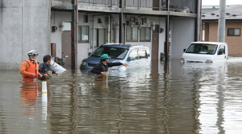
Japan Heavy Rain Event
Japan suffered the worst flooding and landslide in decades, with many daily rainfall records broken between 28 June and 8 July. According to official government figures, more than 200 people lost their lives. Around 10,000 houses have been destroyed and/or inundated.
Japan is one of the world’s best prepared countries for disaster risk reduction and disaster management. JMA issued emergency warnings in advance, targeting as many as eleven prefectures in the country to alert people to the significant likelihood of catastrophes. The emergency warning system was launched by JMA in 2013, based on lessons from the major tsunami caused by the 2011 Great East Japan Earthquake. In addition, JMA dispatched its experts as the JMA Emergency Task Team or JETT, to local governments in the region to best support multi-hazard disaster prevention activities. It set up a web portal dedicated to the heavy rain event.
Between 28 June and 8 July, there was extraordinarily heavy rainfall caused by a huge amount of water vapor from a stationary rainy front, in addition to damp air remaining from Typhoon Prapiroon. West Japan and Hokkaido experienced record precipitation during the period, according to the Japan Meteorological Agency (JMA).
Total precipitation at many observation sites reached two- to four times the mean monthly precipitation for July. For instance, 1,800 mm of rain fell in Shikoku, 1,200 mm in Tokai, 900 mm in North Kyushu, 600 mm in Kinki, and 500 mm in Chugoku. This triggered a large number of landslide, inundation and flood events.
Relationship with Climate Change
Episodes of extreme heat and precipitation are increasing as a result of climate change. Although it is not possible to attribute the individual extreme events of June and July to climate change, they are compatible with the general long-term trend due to rising concentrations of greenhouse gases.
Many recent studies have found that the probability of the extreme event has been influenced by human activity, either directly or indirectly. Of a set of 131 studies published between 2011 and 2016 in the Bulletin of the American Meteorological Society, 65% found that the event’s probability was significantly affected by anthropogenic activities. In the case of some extreme high temperatures, the probability increased by a factor of ten or more.
It has been more difficult to identify anthropogenic influence in the attribution of precipitation extremes. Whilst some studies have found that the probability of some extreme precipitation events was increased, most often indirectly, by climate change, for many other studies the results have been inconclusive. This is because the underlying long-term climate signal in extreme precipitation is less clear than it is for temperature and, because extreme precipitation events typically occur on shorter spatial scales than extreme temperature events. At present, attribution studies are mostly carried out in research mode in peer-reviewed literature.
The IPCC 2012 Special Report on Extreme Events anticipates for example that “it is likely that the frequency of heavy precipitation or the proportion of total rainfall from heavy falls will increase in this century over many areas of the globe” and that “a 1-in-20 year annual maximum daily precipitation amount is likely to become a 1-in-5 to 1-in-15 year event by the end of the 21st century in many regions”.